Asheville, North Carolina, August 13, 2025
News Summary
Residents of Western North Carolina are on alert as widespread showers and scattered thunderstorms may lead to severe flash flooding this afternoon and evening. The National Weather Service has forecasted up to 3 inches of rain, particularly in the North Carolina Foothills. With elevated flood risks and muggy conditions, residents are advised to stay informed and avoid driving through flooded areas. Tropical Storm Erin has also formed off the coast but poses no immediate threat to the region.
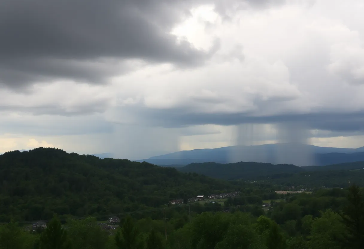
Asheville, North Carolina — Widespread showers and scattered thunderstorms are set to sweep through Western North Carolina this afternoon and evening, raising concerns over possible flash flooding in certain areas. The National Weather Service (NWS) in Greenville-Spartanburg has indicated that some regions could see rainfall totals between 1 to 3 inches, particularly along and west of the Interstate 26 corridor.
The heaviest amounts of rainfall are projected to occur in the North Carolina Foothills, where saturated ground conditions might escalate the risk of isolated flooding in low-lying and poorly drained areas. As multiple rounds of storms are expected to persist into tonight, residents should remain vigilant.
Muggy conditions and high temperatures struggling to reach the low 80s will further characterize the day’s weather, contributing to the overall discomfort. Rain chances remain elevated with an 80 percent likelihood of showers and thunderstorms on Wednesday and a 60 percent chance on Thursday. Experts have noted that typical summertime afternoon storms could be a regular occurrence as we move through the week.
With Tropical Storm Erin forming off the coast of Africa on Monday, forecasters are anticipating its gradual strengthening into a hurricane. Fortunately, there is no immediate threat to the Carolinas or northeast Georgia from this storm.
Additionally, the Asheville Regional Airport has already experienced its wettest day in May so far, recording 2.78 inches of rain on May 8. With 4.79 inches of rain recorded for May to date, the airport is currently over three inches above average for the month. As the week progresses, additional showers and thunderstorms are expected, potentially adding another inch of rain, with higher amounts possible in some isolated storms.
Given the wet ground and full streams and creeks, the risks associated with flooding and landslides have also increased. Residents are advised to remain weather aware and to prepare to move to higher ground if a Flash Flood Warning is issued. Authorities emphasize the importance of avoiding water-covered roads and being alert for changing conditions, especially when driving.
The forecast for today suggests scattered showers before noon, transitioning to more widespread rain and thunderstorms post-1 p.m. Temperatures are expected to hover around 80 degrees, accompanied by light winds.
Weather Summary
- Current Weather: Widespread showers and thunderstorms
- Rainfall Forecast: 1 to 3 inches expected, with heaviest rain in the North Carolina Foothills
- Flood Risk: Increased risk of flooding in low-lying areas
- Temperature: Highs around 80 degrees with muggy conditions
- Upcoming Days: 80% chance of rain on Wednesday, 60% on Thursday
Preparedness Measures
- Be alert for Flash Flood Warnings
- Avoid driving through flooded roadways
- Prepare to move to higher ground if necessary
Background Information
Western North Carolina experiences a typical weather pattern consisting of summer storms, particularly during this time of year. Local authorities and meteorologists continue to monitor conditions as they can change rapidly.
It is crucial for residents to stay updated and informed about severe weather warnings and to understand how to react effectively to minimize risks during adverse weather events.
Frequently Asked Questions
What areas are expected to receive heavy rainfall?
Western North Carolina, particularly the North Carolina Foothills and areas along and west of the Interstate 26 corridor.
How much rain is expected?
Rainfall totals between 1 to 3 inches are possible, with isolated heavier amounts in thunderstorms.
Are there any flood risks associated with this weather?
Yes, saturated ground conditions will increase the risk of isolated flooding in low-lying or poorly drained areas.
What precautions should residents take?
Residents should be weather aware, prepared to move to higher ground if a Flash Flood Warning is issued, and avoid driving through water-covered roads.
What is the temperature forecast for today?
Highs are expected to be around 80 degrees, with humid conditions prevailing.
Deeper Dive: News & Info About This Topic
HERE Resources
John McClung Roofing Hosts Annual Backpack Giveaway in Asheville
Severe Weather Warning for Asheville Residents
Asheville Set to Celebrate Marquee Reopening After Floods
Buncombe County Faces Severe Winter Weather and Shelter Demand
Asheville Supports Residents After Tropical Storm Helene
Asheville Community Receives Essential Services from Local Church and Convoy
Cool Weather Hits Asheville and Western North Carolina
Buncombe County Updates Recovery Efforts from Tropical Storm Helene
Asheville Celebrates National Chocolate Chip Cookie Day
Asheville, NC Registers Record Low Temperatures
Additional Resources
- 828 News Now: Heavy Rain Storms Expected Across Asheville Area
- Wikipedia: Weather
- WLOS: Western North Carolina Weather Summary
- Google Search: Asheville Weather
- 828 News Now: Umbrellas Needed, Rain Chances High

Author: STAFF HERE ASHEVILLE WRITER
The ASHEVILLE STAFF WRITER represents the experienced team at HEREAsheville.com, your go-to source for actionable local news and information in Asheville, Buncombe County, and beyond. Specializing in "news you can use," we cover essential topics like product reviews for personal and business needs, local business directories, politics, real estate trends, neighborhood insights, and state news affecting the area—with deep expertise drawn from years of dedicated reporting and strong community input, including local press releases and business updates. We deliver top reporting on high-value events such as the Asheville Bread Festival, LEAF Festival, and mountain sports tournaments at Biltmore Estate. Our coverage extends to key organizations like the Asheville Area Chamber of Commerce and Explore Asheville Convention & Visitors Bureau, plus leading businesses in hospitality and brewing that power the local economy such as the Biltmore Estate and Sierra Nevada Brewing Company. As part of the broader HERE network, including HERECharlotte.com, HEREGreensboro.com, HERERaleigh.com, and HEREOBX.com, we provide comprehensive, credible insights into North Carolina's dynamic landscape.